


Resources
Wind power; is a natural, renewable, clean, and infinite power and its source is the sun. A small amount of 1-2% of the energy that the sun sends to the earth turns into wind energy. Airflow occurs due to the difference in temperature and pressure that occurs as a result of the sun not heating the ground surface and atmosphere homogeneously. If an air mass warms up more than its current state, it rises above the atmosphere, and with the rise of this air mass, the mass of cold air in the same volume settles in the vacated space. The displacement of these air masses is called wind.
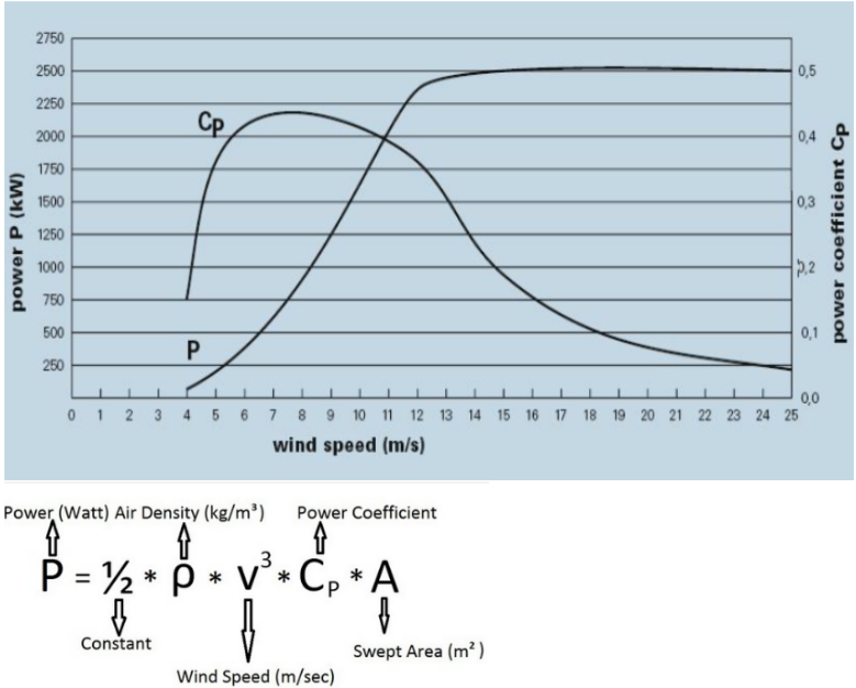
In other words, wind; It is the airflow that occurs due to the pressure differences between the two adjacent pressure zones and moves from the high-pressure center to the low-pressure center. While winds flow from high-pressure areas to low-pressure areas; it is shaped by reasons such as the earth rotating around its own axis, surface friction, local heat dissipation, different atmospheric events in front of the wind, and the topographic structure of the land. The characteristics of the wind vary temporally and locally due to local geographical differences and inhomogeneous heating of the earth. The wind is expressed by two parameters, speed, and direction. Wind speed increases with altitude and its theoretical power changes in proportion to the cube of its speed.
- Technical and administrative studies are carried out to identify Candidate YEKAs based on wind energy.
- Specification and Contract drafts are prepared for the allocation of the usage rights of the connection capacities based on wind energy (YEKA-RES) and the relevant processes are managed by organizing competitions for these allocations.
- Suggestions for the evaluation of wind energy resources are developed.
- Necessary studies are carried out by improving the investment environment related to wind energy, ensuring lean processes, determining the problems encountered by the investors in practice, and coordinating with the relevant institutions/organizations and the sector regarding the measures to be taken.
- Studies are carried out for conducting technical evaluations of applications for associate or unlicensed electricity generation based on the wind source, for the requests for changes related to coordinate changes, capacity increases, and turbine technical features of the projects whose technical evaluations have been concluded.
- Opinions are created on the suitability of Wind Measurement Station (RÖI) locations, which must be installed by those who wish to apply for associate degree applications.
- Providing point or areal wind source information to the demanders by increasing the data depth of the Wind Energy Potential Atlas (REPA), ensuring that it is developed and kept up to date.
- Responsible works and procedures are carried out with regard to the Technical Interaction Analysis Reports prepared by TÜBİTAK to determine the interaction of wind turbines to the communication, navigation and radar systems operated under the responsibility of the Ministry of Interior, Ministry of National Defense and the Directorate of National Intelligence Service.
- Opinions regarding the proposed development plans and EIA reports are presented for the wind farms planned to be established.
- To evaluate the interactions of licensed mining sites and wind turbines planned to be established with each other and to give opinions in this direction.
- Studies on overground wind power plants are followed.
- Activities related to the creation of the 12th Wave Energy Potential Atlas (DEPA) are monitored.
- Participation in national & international projects and collaborations is ensured.
- Problems encountered in wind investments are identified and suggestions to solve problems are developed, legislation drafts are prepared within this scope or existing ones are improved.
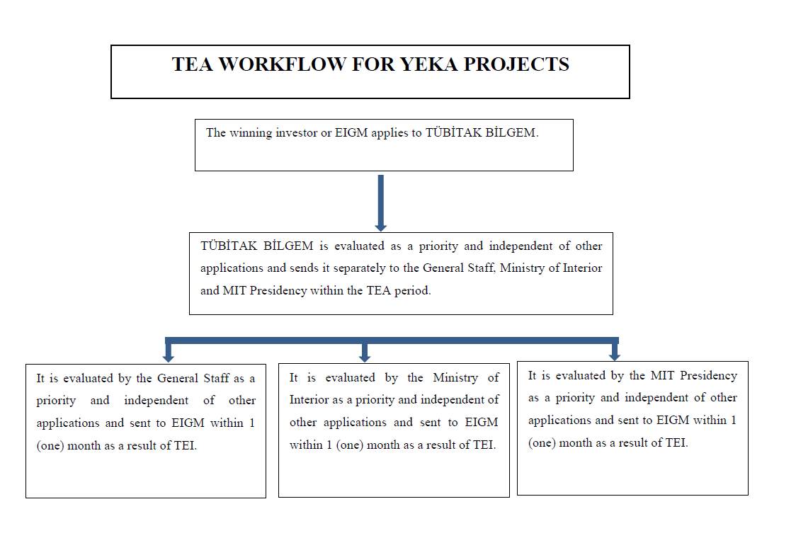
Between the Ministry of General Staff, the Ministry of Internal Affairs, MİT, EPDK (EMRA), TÜBİTAK and TEİAŞ, “The Protocol on the Establishment of Permission Processes for the Interaction of the Communication, Navigation and Radar Systems Operated under the Responsibility of the General Staff Presidency and the Systems Operated under the Responsibility of the Ministry of Interior and MIT. Coordination of all works within the scope of ”is ensured with the Parties and third parties. For unlicensed WPP projects, a loan is provided to the connection agreement of the relevant project in terms of commitments. In line with the requests of the third parties for the relevant projects, meetings were held with the relevant parties to the Protocol.
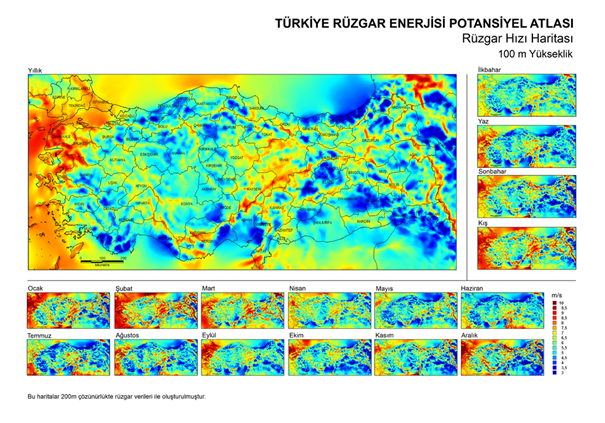
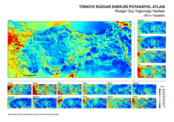
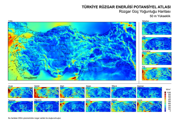
Türkiye in order to determine the potential of wind energy was developed in 2007. The wind source information and dynamic structured thematic maps given in this atlas are important information for wind energy applications and other fields of activity that should be taken into account (fighting forest fires, monitoring air pollution concentrations, mountain, and sea sports, maritime activities, agricultural practices, etc.). provides infrastructure.
Türkiye Wind Energy Potential Atlas; A small scale wind of 200 m spatial resolution that adds topography and local effects to the calculations with the meteorological data (speed, direction, temperature, pressure) produced by the medium-scale digital weather forecast model WRF (Weather Research and Forecast Model), which is operated at 5 km spatial resolution. prepared using a flow model and geographic information system (GIS) software. Türkiye can not be used in areas from the total area wind potential calculations have been made for the remaining areas after removal. In these calculations; 50 m above ground level. It is accepted that a wind power plant with a power of 5 MW per square kilometer can be installed in areas with high wind speeds of 7.5 m/s and above. These assumptions light wind energy potential in Türkiye is determined to be 47,850 MW.
With REPA, wind source areas that can be invested in wind energy applications are easily identified, pre-feasibility studies can be made, efforts to search for wind sources are eliminated, and time and economic savings are achieved, and users and energy planners are made to make data-based decisions.
Application and Follow-up of Wind Power Source Information on Point and Field Sales

Although solar energy technologies started in an experimental and narrow scope at the beginning, today it has become a new commercial sector, especially in terms of residential technologies. Especially being a clean energy source and working at almost zero cost after installation increases the importance of solar energy. Solar energy is used today as an alternative solution in developed countries to alleviate the environmental problems caused by fossil fuels. It is not possible to provide the energy requirement needed for industry, residences or individual uses, directly from the sun as in plants. For this reason, solar energy can be used in various ways. Many technologies have been developed to take advantage of the sun's rays. Although solar energy technologies vary widely in terms of method, material and technological level, some of them use solar energy directly as light or heat energy, while other technologies are used to obtain electricity from solar energy. Areas of use of solar energy include direct or indirect electricity generation, obtaining hot water, space heating and cooling, process heat energy for industrial organizations and greenhouse heating.
Solar energy is the radiant energy released by the fusion process (the conversion of hydrogen gas to helium) located in the core of the sun. Outside the earth's atmosphere, the intensity of solar energy is approximately 1370 W / m², but the amount reaching the earth varies between 0-1100 W / m2 due to the atmosphere. Even a small portion of this energy that comes to the world is many times more than the current energy consumption of humanity. Studies on solar energy utilization have gained speed especially after 1970s, solar energy systems have shown a technological progress and a decrease in terms of cost, and have established themselves as an environmentally clean energy source.
- Technical and administrative studies are carried out to determine the candidate YEKAs based on solar energy
- Specification and Contract drafts are prepared for the allocation of the usage rights of the connection capacities with the solar energy resource areas (YEKA-GES), and competitions are organized for these allocations, and the relevant processes are followed.
- By developing projections and suggestions for the evaluation of solar energy resources, it is monitored to identify the problems encountered in the related investments and to improve the investment environment, to ensure that the processes are lean, to identify the problems encountered by the investors in practice and to ensure coordination with the relevant institutions/organizations and the sector regarding the measures to be taken.
- Carrying out technical studies, preparing/drafting legislative drafts, or improving existing ones are developed and attention is paid to ensure coordination with relevant institutions/organizations.
- Studies are carried out to monitor and control solar power plants.
- Technical evaluation processes of unlicensed production applications and pre-license applications based on solar energy are carried out.
- Implementation studies are carried out for passive applications of solar energy and for the use of heating, cooling, and lighting.
- Increasing the data depth of the Solar Energy Potential Atlas (GEPA) is ensured to be developed and kept up to date.
- Analyzes the effects of an absorber or reflective surfaces used in solar power plants on highways, railways, and airways, and reported to the requesting institutions.
- Opinions are created for the proposed zoning plans for the solar power plants planned to be established.
- Participation in national & international projects and collaborations is ensured.
Established within the scope of unlicensed activities in line with the provisions of Article 14 of Law no 6446, technical studies are carried out to ensure that electricity is produced at the point where electricity is consumed, and to encourage self-consumption, to promote solar energy production in roofs, in electricity generation facilities based on renewable energy sources, at the point where electricity is consumed and related. Correspondence is carried out by coordinating with institutions / organizations and draft legislation is being prepared.
If requested by DHMİ, General Directorate of Highways Directorate of State Highways and General Directorate of State Airports Authority within the scope of article 9 titled “Glare Analysis” of the Regulation on Technical Assessment of Solar Energy Based Electricity Generation Facility Applications published in the Official Gazette dated 30/06/2017 and numbered 30110. Glare/luminescence analysis is conducted on the effects of an absorber or reflective surfaces used in solar power plants on highways and airways and the results are reported to the relevant institutions.
- Where are the best areas in terms of solar energy application in our country,
- Electricity or heat energy production opportunities based on solar energy in these designated places,
- In determining the source of solar energy in the Atlas area and in determining high solar potential regions
- In the next step, in the first study, by presenting the necessary solar resource information together with other parameters required in solar energy applications to conduct a further detailed examination.
- High-resolution solar source maps and information from these maps provide services to a wide range of users, such as government planners, energy service companies, private entrepreneurs, businesses, and land/landlords.
- With direct access to the most up-to-date and complete information about the solar source, these products enable users to make data-driven decisions.
- At the local level, these products, for example, determine the feasibility of a local solar application.
- How much solar potential is there in the designated area,
- Where are the best areas,
- What is the probability of developing Economic Solar,
- What are the most obvious barriers and encouraging qualities,
- What is the electricity production cost, etc.
- The region that receives the least amount of radiation is the Central and Eastern Black Sea Region. This region has both latitude value and a humid climate. Excess water vapor in the atmosphere causes the screening of the radiation.
- Marmara and North Aegean regions are slightly better than the Black Sea.
- The Southern Aegean, Western Mediterranean, and Central Anatolian Regions receive moderate radiation.
- Eastern Mediterranean and Eastern Anatolia Regions are our regions with good radiation values.
- Fighting forest fires,
- Monitoring air pollution concentrations,
- Mountain and sea sports,
- Maritime activities,
- Agricultural practices,
- Construction industry,
- Aviation
Türkiye world over 36o - 42o north latitude and 26o - 45o is located between east longitude. Our country is located in the sunbelt and has an important potential in this regard. Our country is fortunate compared to many countries in terms of its solar energy potential due to its geographical location. all on an annual basis with the geographic location where the reputation of our province Türkiye is a country with great potential enough to obtain electricity from solar energy. In other words, it is possible to obtain electricity from the Sun with good feasibility throughout our country. Türkiye Solar Energy Potential Atlas (GEP), Türkiye has been produced in order to determine the characteristics and distribution of solar resources. In other words, according to the solar energy potential determination studies;
A SOLAR ENERGY POTENTIAL ATLAS (GEPA) was created to identify such topics. A solar energy atlas,
On a large scale, it helps to answer such questions.
It is extremely difficult for today to determine the solar potential of our country as a whole and to determine it with numbers. To take advantage of solar energy, the solar potential and the solar properties of the region or region must first be determined. The creation of the meteorological basis in this regard is more important than other purposes to be established on this basis. The fact that the sun is highly dependent on the meteorological and topographic structure due to its nature makes the studies of potential determination more difficult. Solar energy can also be found in different places because the solar potential in Türkiye may be regional. Using the existing GEPA Geographic Information Systems Techniques and satellite images, solar potential has been determined and later product imaging software has been developed and additional features have been gained. GEPA does not have time-series data, but only annual, seasonal, and monthly average Solar data values. In addition, in its newly developed version, GEPA includes not only the Sun values of the average year but also the data of the real years. In this way, it is possible to obtain data specific to a particular year. Solar resource information, supported by Türkiye in general thematic maps, grids, geographic regions, provinces, and can be queried any area or point to be chosen. Within the scope of these studies, measurements and analyzes are still continuing in different parts of our country today. Taking advantage of the studies, the Solar Observation Station (GGİ) was established in appropriate places. The results of the study conducted in different places for many years show that differently from the MGM records, solar energy can be used in various places. The Solar Energy Potential Atlas (GEPA) has been completed and a product imaging software album has been prepared and presented to the users via the website of our General Directorate. Users can easily learn the city and district-based solar energy potentials and sunbathing times via the internet page. Thus, the areas where the solar power plant can be established can be easily determined, pre-feasibility studies can be carried out, and the efforts to search for a solar source are eliminated and savings are achieved. Detailed solar resource maps and other information provided in this atlas provide a substructure that can be used to identify candidate regions from solar energy to electricity generation. Many investors who want to establish production facilities based on solar energy in our country can obtain the Solar source information of the fields they are interested in by applying to the General Directorate of Energy Affairs.
The energy potential that can be produced from the sun is a minimum of around 380 billion kWh. Türkiye's gross solar energy technical potential 87.5 Million Tons of Oil Equivalent (TOE) is the size. 26.5% of this value is suitable for thermal use and 8.75% for generating electricity.
According to the Solar Energy Potential Atlas (GEPA);
1. Average annual total sunbathing time = 2766.5 hours/year
2. Average daily total sunshine time = 7.58 hours/day
3. Average annual total radiation intensity = 1521.7 kWh / m2-year
4. Average daily total radiation intensity = 4.17 kWh / m2-day
calculated as.
The number of days that can benefit from the sun efficiently is as high as 110 days a year. During the 10 months of the year, it can be used technically and economically at 63% of the country's surface area and 17% throughout the year. The solar energy potential of Türkiye and sunshine duration values are given in Table by months.
Table: Türkiye's Monthly Average Solar Potential
MONTHS | MONTHLY TOTAL SOLAR ENERGY | SOLAR TIME | |
(kcal/cm2-month) | (kWh/m2-month) | (hour/month) | |
| JANUARY | 4.45 | 51.75 | 103.0 |
| FEBRUARY | 5.44 | 63.27 | 115.0 |
| MARCH | 8.31 | 96.65 | 165.0 |
| APRIL | 10.51 | 122.23 | 197.0 |
| MAY | 13.23 | 153.86 | 273.0 |
| JUNE | 14.51 | 168.75 | 325.0 |
| JULY | 15.08 | 175.38 | 365.0 |
| AUGUST | 13.62 | 158.40 | 343.0 |
| SEPTEMBER | 10.60 | 123.28 | 280.0 |
| OCTOBER | 7.73 | 89.90 | 214.0 |
| NOVEMBER | 5.23 | 60.82 | 157.0 |
| DECEMBER | 4.03 | 46.87 | 103.0 |
TOTAL | 112.74 | 1311 | 2640 |
AVERAGE | 308.0 cal/cm2-day | 3.6 kWh/m2-day | 7.2 hour /day |
Türkiye's most 42º northern latitudes with 36º south latitude, which is the form the boundaries of research. According to months, max. radiation values were taken. For example, total daily radiation in December at 36º max latitude max. It is 6.200 kcal / m2 (25.916 kW / m2) and has S = 60º value. In December and at 42º latitude max. Total daily radiation is taken with S = 66º and its value is 5.300 kcal / m2 (22.154 kW / m2).
The distribution of the annual total solar energy potential of our country according to our geographical regions is shown in the Table.
Table: Türkiye's Total Annual Potential of Solar Energy Distribution by Region
| REGIONS | TOTAL ENERGY ( kWh/m2/year ) | SOLAR TIME ( hour/year ) |
| SOUTHEASTERN ANATOLIA | 1460 | 2993 |
| MEDITERRANEAN | 1390 | 2956 |
| EASTERN ANATOLIA | 1365 | 2664 |
| CENTRAL ANATOLIA | 1314 | 2628 |
| AEGEAN | 1304 | 2738 |
| MARMARA | 1168 | 2409 |
| BLACK SEA | 1120 | 1971 |
Türkiye's potential to benefit from solar energy is that most of the Southeastern Anatolia Region. The Mediterranean Region is our second place.
The lower right end of the South East Region is our region with the best irradiation values. This place, which has a hard and cold climate, is the place that receives the most radiation in winter. Altitude is high. Water vapor in the air condenses in the form of rain and snow, and the atmosphere is clearer, and radiation shielding is minimal.
Official institutions and energy companies are used to adapt these maps to their own personal energy programs. In short, this solar mapping initiative is useful in technology transfer activities, as well as in making forward-looking solar energy planning and deployment decisions, using advanced modeling techniques to improve access to key planning parameters. GEPA reflects its use for solar energy purposes;
can contribute to the development of many sectors such as.